Use Finder
Part 2A. Introduction
Div. 2A.1. Orientation
Sec. 2A.1.1. Relationship to Zone String
A zone string is composed of the following districts:

The Form District is a separate and independent component of each zone.
Sec. 2A.1.2. How to Use Article 2. (Form)
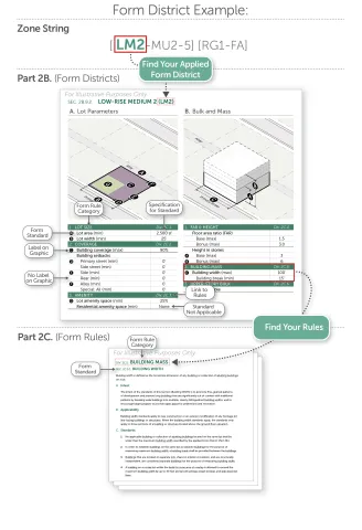
Identify the Applicable Form District
The first component in a zone string is the Form District applied to a property.
Determine Applicable Form District Standards
Form Districts standards are outlined in Part 2B. (Form Districts). Each Form District page identifies the standards specific to that Form District.
Each standard on a Form District page in Part 2B. (Form Districts) provides a reference to Part 2C. (Form Rules) where the standard is explained in detail. Text in italics below a heading provides a definition of that heading.

Sec. 2A.1.3. Form District Diagrams
General
Diagrams and illustrations within this Article (Form) are provided to assist users in understanding the intent and requirements of the text. In the event a conflict occurs between the text of this Article (Form) and any illustration or graphic, the text prevails.
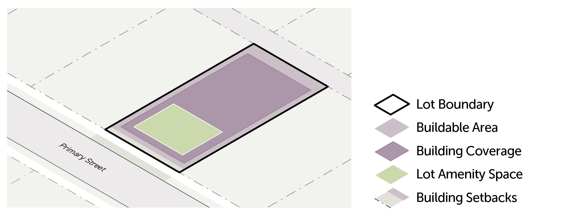
Lot Parameter Diagrams

Lot Boundary
This line represents the perimeter of the subject lot, serving as a reference for both lot area and lot width.
Buildable Area
This shape represents the area on a lot where buildings are allowed, reduced by required building setbacks, or the lot boundary when no setback is required.
Building Setbacks
The area between a lot boundary and the minimum required setback, represented with a dotted white line and bounded by the buildable area.
Building Coverage
This shape represents the total building coverage allowed in proportion to the lot area, but does not reflect any requirement as to the location or configuration of any buildings or structures.
Lot Amenity Space
This shape represents the total lot amenity space required in proportion to the lot area, but does not reflect any requirement as to the location or configuration of any amenity space.
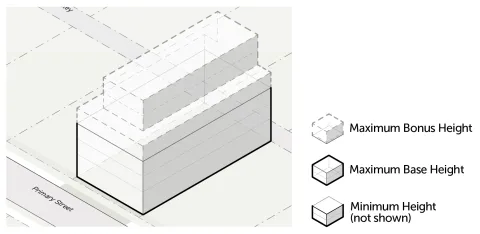
Bulk and Mass Diagrams
General
Bulk and mass diagrams represent the volume where a building is allowed to be located by showing the maximum height allowed for the entire buildable area. The volume does not represent the massing of an allowed building. Other standards, such as maximum building coverage and floor area ratio (FAR), may limit the ability for a building to fill the full volume.
Form Districts (Part 2B.) that include a maximum height standard and those that do not include a height limit are represented differently in the bulk and mass diagram.
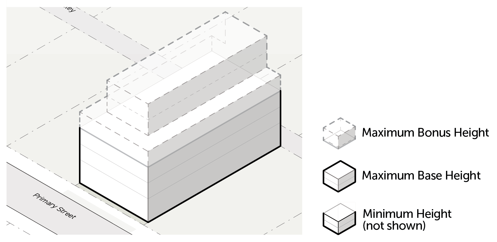
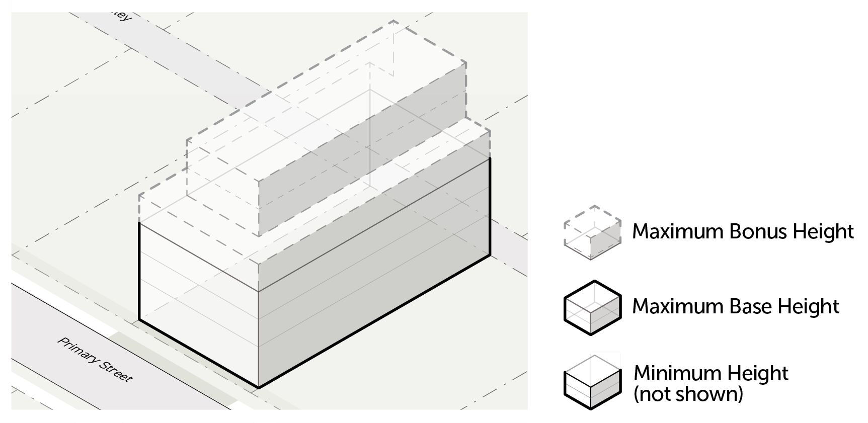
Districts with a Maximum Height Standard
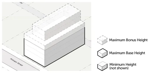
Maximum Bonus Height
Maximum bonus height represents the maximum number of stories allowed beyond the number of stories allowed by the maximum base height in stories.
Maximum Base Height
Maximum base height represents the number of stories allowed without providing public benefits in trade for additional height according to Article 9. (Public Benefit Systems).
Minimum Height
Minimum height represents the lowest number of stories required.
Districts with no Maximum Height Standard
Unlimited Height
This volume represents the building height allowed, in addition to the likely height of the building based on maximum Base FAR.
Likely Height Based on Bonus FAR
This volume represents the likely building height based on the maximum allowed bonus FAR, in addition to the likely height of the building based on maximum base FAR.
Likely Height Based on Base FAR
This volume represents the likely building height based on the maximum allowed base FAR, in addition to the minimum required height of the building.
Minimum Height
This volume represents the minimum number of stories required.
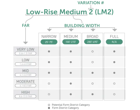
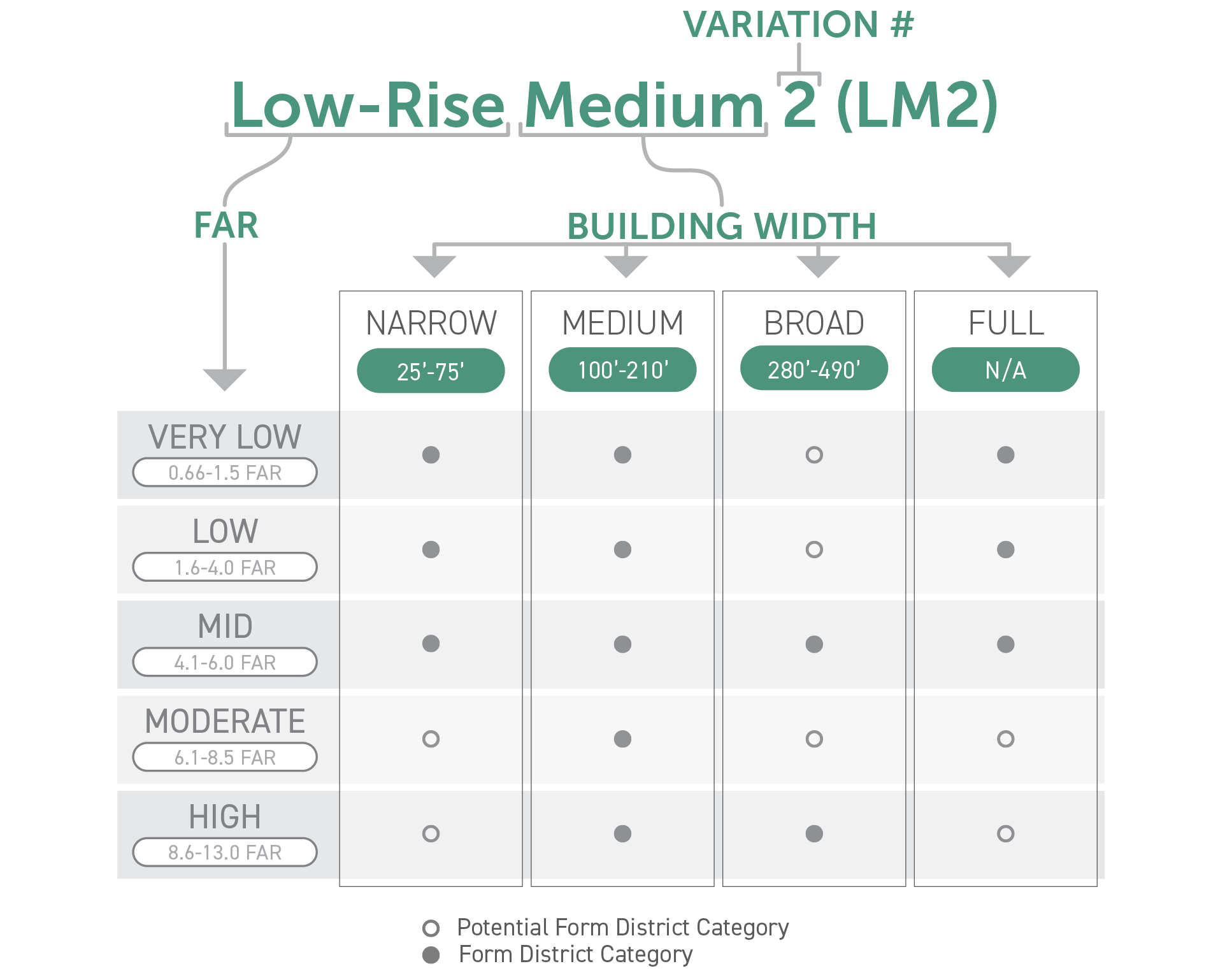
Sec. 2A.1.4. Form District Naming Convention
There are three different types of naming conventions for Form Districts (Part 2B.). Each Form District name is composed of a variety of components that are specific to that district.
Rural & Estate Form Districts
[Reserved]
House Form Districts
[Reserved]
All Other Form Districts
All other Form District names are composed of three components:
FAR Category
The first component of each Form District name is a floor area ratio (FAR) category. FAR categories group all districts within a range of maximum allowed FAR. FAR categories are organized as follows:
Building Width Category
The second component of each Form District name is a building width category. Building width categories group all districts within a range of maximum allowed building width. Each building width category is organized as follows:
Narrow (25 feet - 75 feet)
Medium (100 feet - 210 feet)
Broad (280 feet - 490 feet)
Full (no building width maximum)
Variation Number
The last component of each Form District is a variation number. All Form Districts are numbered in the order they fall within this Article (Form).
Example Form District
Potential Form District categories are shown below to illustrate the naming convention that would be applied to new Form Districts that may be added to this Article (Form) through future code amendments.
Div. 2A.2. General Rules
Sec. 2A.2.1. Form
This Article (Form) regulates the placement, scale, and intensity of buildings and structures on a lot in order to ensure building forms are compatible with their context and promote projects that support community goals.
Sec. 2A.2.2. Form Applicability
General
All projects filed after the effective date of this Zoning Code (Chapter 1A) shall comply with the Form District standards in this Article (Form), as further specified in the applicability statement of each Section in Part 2C. (Form Rules). Form District standards only apply to the project activities listed in each Section's applicability statement in Part 2C. (Form Rules). For vested rights, see Sec. 1.4.5. (Vested Rights), and for continuance of existing development, see Sec. 1.4.6. (Continuance of Existing Development).
Applicable Components of Lots, Buildings, & Structures
Unless otherwise provided, Form District (Part 2B.) standards apply to all portions of a lot and all buildings and structures on a lot.
Nonconformities
Article 12. (Nonconformities) may provide relief from the requirements of this Article (Form) for existing lots, site improvements, buildings, structures, and uses that conformed to the zoning regulations, at the time they were established, but do not conform to current district standards or use permissions. All project activities shall conform with Form District (Part 2B.) standards unless otherwise specified by Div. 12.2. (Form Exceptions).